Water is all around us, often invisible in the air. Yet, sometimes it gathers above our heads as clouds. Understanding how water forms clouds is not just for scientists; it helps us see weather, climate, and even the fresh water cycle in a new light.
This article explains the process in detail, using simple language and real data to make the science clear.
Clouds are more than white shapes in the sky. They are a sign that important changes are happening in the air. By looking closely at how water vapor turns into clouds, we can predict rain, plan our activities, and protect our environment.
As someone who has studied meteorology and watched weather patterns for years, I’ll walk you through the complete story of clouds, from the smallest water droplet to the big puffy formations you see overhead.
The Basics: What Are Clouds?
Clouds are made of tiny water droplets or ice crystals that float in the air. Each droplet is usually less than 0.02 millimeters wide, so small that it would take millions to form a single raindrop. The air holds water in the form of water vapor, which is a gas. When this vapor cools down, it turns back into liquid or ice and forms clouds.
Scientists divide clouds into four main types:
- Cirrus: High, thin, wispy
- Cumulus: Puffy, cotton-like
- Stratus: Flat, layered
- Nimbus: Rain-producing
Each type forms under different conditions and tells us something about the weather.
How Water Turns Into Clouds
The Water Cycle
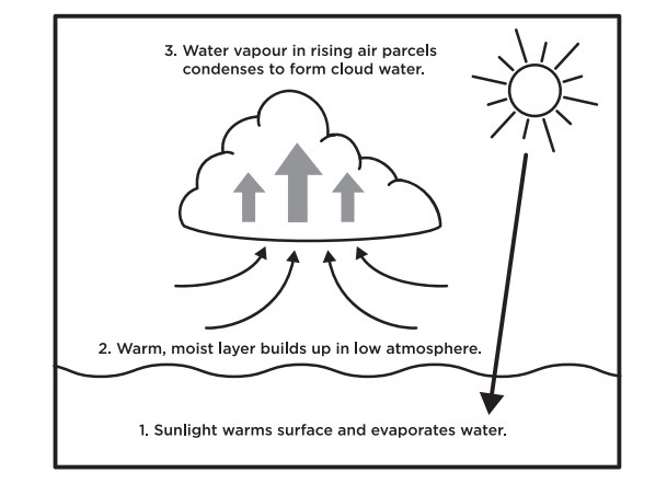
Water moves in a loop called the water cycle. It starts with evaporation, where the sun heats oceans, lakes, and rivers, turning water into vapor. Plants also release water into the air through a process called transpiration.
Once in the air, this vapor rises. As it goes higher, the air gets cooler. Cooler air cannot hold as much vapor, so the vapor begins to turn back into liquid—a process called condensation.
The Role Of Condensation Nuclei
Clouds do not form without help. Water vapor needs a surface to stick to, like dust, salt, or smoke. These tiny particles are called condensation nuclei. Without them, vapor would stay as a gas, and clouds would not appear.
When air cools to the dew point (the temperature where condensation starts), water vapor collects on these nuclei. The droplets cluster together and become visible as clouds.
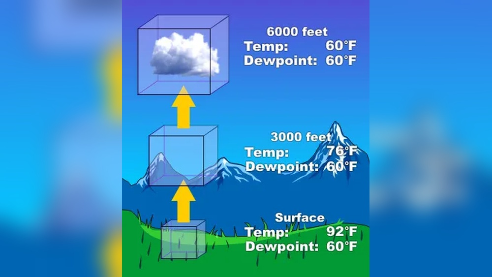
How Altitude Changes Cloud Formation
The height where clouds form depends on temperature and humidity. At higher altitudes, the air is colder, so clouds often form higher up first. For example, cirrus clouds usually form above 6,000 meters (20,000 feet), while stratus clouds can form just a few hundred meters above the ground.
Credit: www.scienceworld.ca
Why Cloud Formation Matters
Clouds do much more than make the sky interesting. Here are some reasons why understanding cloud formation is important:
- Weather Prediction: Clouds signal changes in the weather. For example, growing cumulus clouds can mean a thunderstorm is coming.
- Water Supply: Clouds bring rain and snow, which fill rivers and lakes.
- Climate Regulation: Clouds reflect sunlight and trap heat. They help control the Earth’s temperature.
- Air Travel: Pilots need to know about clouds to fly safely.
Step By Step: How Water Forms A Cloud
Here’s a simple step-by-step guide that shows how water forms clouds:
- Evaporation
- Sun heats water in oceans, rivers, and soil.
- Water turns into vapor and rises into the air.
- Rising Air
- Warm air rises because it is lighter than cool air.
- As it rises, it carries water vapor with it.
- Cooling
- Higher up, the air gets cooler.
- For every 100 meters you go up, the temperature drops about 0.65°C.
- Condensation
- When the air cools to the dew point, vapor turns into liquid droplets.
- Droplets form around dust, salt, or other small particles.
- Cloud Formation
- Millions of these droplets gather together.
- When enough form, a cloud becomes visible.
Let’s summarize this in a simple table:
| Step | What Happens | Key Data |
|---|---|---|
| Evaporation | Sun heats water, turning it to vapor | 70% of Earth’s surface is water |
| Rising Air | Warm air rises, carrying vapor | Air rises 1 km, temp drops 6.5°C |
| Cooling | Air cools as it rises | Dew point varies (usually 0–20°C) |
| Condensation | Vapor turns to droplets on nuclei | Droplets: 0.01–0.02 mm wide |
| Cloud Forms | Droplets gather and become visible | Clouds form at 500–13,000 m altitude |
Credit: phys.org
Practical Examples Of Cloud Formation
Let’s see how this works in real life:
- After Rain: On a sunny day after rain, puddles evaporate quickly. You might notice new clouds form in the sky within an hour.
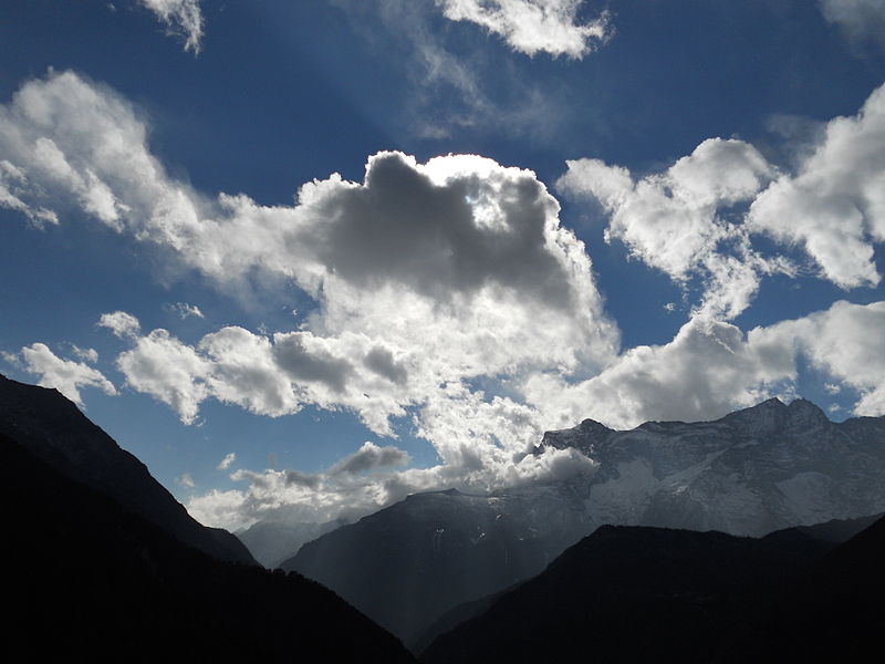
- Mountains: When air moves up a mountain slope, it cools and clouds form at the top. This is why you often see clouds hugging mountain peaks.
- Seashore: Warm, moist air from the sea rises over land and forms clouds, especially in the afternoon.
Signs And Indicators Of Cloud Formation
You can notice several signs that clouds are about to form:
- Increasing Humidity: Sticky feeling in the air means more water vapor.
- Cooling Temperatures: Cooler evenings often lead to cloud formation overnight.
- Hazy Sky: Haze can mean that condensation nuclei are present and clouds may soon form.
- Rising Air Currents: Birds or insects flying higher than usual may be taking advantage of these currents.
Credit: newscenter.lbl.gov
Common Problems And Solutions
Cloud formation is not always simple. Here are some issues that affect how clouds form:
Insufficient Condensation Nuclei
If the air is very clean, there may not be enough particles for droplets to form. This can delay cloud formation even when humidity is high.
Solution: Dust, sea salt, and even pollution often provide enough particles. In rare cases, cloud seeding with artificial particles helps trigger rain.
Air That Does Not Rise
If the air near the ground is cooler than the air above, it won’t rise. This is called a temperature inversion. Clouds cannot form easily in these conditions.
Solution: Waiting for the sun to heat the ground usually solves this, making the air unstable again.
Too Little Water Vapor
Dry air will not form clouds, even if it cools. This often happens in deserts.
Solution: Only when more moisture enters the air, such as after rain, can clouds form.
Strong Winds
High winds can break up forming clouds, making the sky look clear even when there is moisture.
Solution: Clouds may form downwind, where the air is calmer.
Maintenance Tips For Observing Clouds
Like any natural process, watching clouds and understanding their changes takes practice. Here are some tips:
- Record Observations
- Keep a sky journal. Note the time, weather, and types of clouds you see.
- Check Humidity and Temperature
- Use a simple weather app or a home hygrometer to monitor humidity.
- Watch for Changing Patterns
- Notice how clouds grow, shrink, or change shape. Fast changes often mean weather is coming.
- Use Binoculars
- A small pair can help you see details in cloud structure.
- Read Weather Maps
- These show where clouds are likely to form and move.
Why Understanding Cloud Formation Is Valuable
Learning about clouds gives you a powerful tool to read the sky. Farmers use cloud changes to plan planting and harvest. Hikers check clouds to avoid storms. Even city dwellers rely on cloud forecasts to plan their day.
Clouds are also part of climate science. Scientists use satellite data to measure cloud cover. For example, NASA satellites show that about 67 percent of Earth’s surface is covered by clouds at any time. This affects how much sunlight reaches the ground and how much heat escapes to space.
For more about the science of clouds, see this Wikipedia page on clouds.
Key Data And Comparison
Here is a quick comparison of different cloud types and where they form:
| Cloud Type | Altitude (meters) | Appearance | Main Weather |
|---|---|---|---|
| Cirrus | 6,000–13,000 | Thin, wispy | Fair, changing weather |
| Cumulus | 500–3,000 | Puffy, white | Fair, showers possible |
| Stratus | 0–2,000 | Flat, gray | Drizzle, overcast |
| Nimbus | Varies | Thick, dark | Rain or storms |
Frequently Asked Questions
How Long Does It Take For Clouds To Form?
Clouds can form in as little as 15 to 30 minutes if conditions are right, especially after a quick change in temperature or humidity. In some cases, cloud formation takes hours as air slowly rises and cools.
Do All Clouds Bring Rain?
No, most clouds do not bring rain. Only thick, dense clouds like nimbus or cumulonimbus carry enough moisture to produce rain or snow. Many clouds just pass overhead with no precipitation.
Can Clouds Form At Night?
Yes, clouds can form at any time. At night, cooling air often leads to new clouds, especially stratus or fog near the ground, as temperatures reach the dew point.
Why Do Clouds Sometimes Disappear?
Clouds disappear when the air warms up or becomes drier, causing the droplets to evaporate. Strong sunlight, dry winds, or descending air can quickly clear the sky.
Is Cloud Seeding Real?
Yes, cloud seeding is a real technique used to encourage rain by adding particles like silver iodide to clouds. It is used in some countries, but results can vary and it depends on having enough moisture present. For more details, see NASA’s overview on cloud seeding.
Key Takeaway
Clouds form through a simple, natural cycle: water rises as vapor, cools, and condenses into tiny droplets that gather as clouds. This process is vital for weather, water resources, and climate balance. By understanding the steps and watching the signs, anyone can read the sky and predict changes. Whether you are a student, traveler, or just curious, knowing how water forms clouds connects you to the rhythms of the Earth.

Hasan Al Sarker is a Reverse Osmosis Specialist. He has worked for many years to ensure safe drinking water for all. His research paper has been published in several journals, including Issue, Medium, and Slideshare. He is recognized as a water doctor among specialists though he did not attend medical college.
Besides working as a researcher of reverse osmosis technology, he is also very fancy with the kitchen and cooking. His guides are reading thousands of people every day. As a head of content, he is responsible for all the published articles at RO System Reviews.